Address: 2500 (From 2500 To 2599) MANNING CIR, KAILUA, HI 96734-49ND, USA
What's 96734-49ND? 96734-49ND is a ZIP Code 5 Plus 4 number of 2500 (From 2500 To 2599) MANNING CIR, KAILUA, HI, USA. Below is detail information.
96734-49ND Basic Information

Street Predirectional?
A geographic direction that precedes the street name.
| Street?
The official name of a street as assigned by a local governing authority. The Street Name column contains only the street name and does not include directionals (EAST, WEST, etc.) or suffixes (ST, DR, BLVD, etc.). This element may also contain literals, such as PO BOX, GENERAL DELIVERY, USS, PSC, or UNIT. Numeric street names that have numeric components that are four characters (or less) in length at are justified such that the low-order digit of the number is positioned in the fourth position of the street name column. This shift is made so that the numeric street names appear in numeric sequence.
| Street Suffix?
The street suffix:
For Example:
ST = Street
RD = Road
DR = Drive
LN = Lane
| City | Record Type?
An alphabetic value that identifies the type of data in the record. Record type codes include the following:
G = General delivery
H = Highrise
F = Firm
S = Street
P = PO box
R = Rural route/highway contract
| Status |
|---|---|---|---|---|---|
| ARNADO | ST | KAILUA | S | valid | |
| FOSTER | DR | KAILUA | S | valid | |
| GIER | ST | KAILUA | S | valid | |
| IOPA | LN | KAILUA | S | valid | |
| MANNING | CT | KAILUA | S | valid | |
| MANNING | ST | KAILUA | S | valid | |
| MARINO | LN | KAILUA | S | valid | |
| PADILLA | DR | KAILUA | S | valid | |
| PARO | DR | KAILUA | S | valid | |
| REEVES | RD | KAILUA | S | valid | |
| SUAPAIA | DR | KAILUA | S | valid | |
| TAUANUU | LN | KAILUA | S | valid | |
| TOMA | DR | KAILUA | S | valid | |
| TSUE | LN | KAILUA | S | valid | |
| WAIKULU | DR | KAILUA | S | valid | |
| CAIN | LN | KAILUA | S | valid | |
| HALLIGAN | RD | KAILUA | S | valid | |
| MAGAOAY | LN | KAILUA | S | valid | |
| MANNING | PL | KAILUA | S | valid | |
| MANNING | CIR | KAILUA | S | valid |
Address

96734-49ND corresponds to the following addresses.
| Address List | Status |
|---|---|
| 7601 (From 7601 To 7699) ARNADO ST, KAILUA, HI 96734-49ND, USA | valid |
| 6300 (From 6300 To 6398) FOSTER DR, KAILUA, HI 96734-49ND, USA | valid |
| 6301 (From 6301 To 6399) GIER ST, KAILUA, HI 96734-49ND, USA | valid |
| 3000 (From 3000 To 3098) IOPA LN, KAILUA, HI 96734-49ND, USA | valid |
| 1200 (From 1200 To 1299) MANNING CT, KAILUA, HI 96734-49ND, USA | valid |
| 2500 (From 2500 To 2599) MANNING ST, KAILUA, HI 96734-49ND, USA | valid |
| 1601 (From 1601 To 1699) MARINO LN, KAILUA, HI 96734-49ND, USA | valid |
| 6201 (From 6201 To 6299) PADILLA DR, KAILUA, HI 96734-49ND, USA | valid |
| 6300 (From 6300 To 6398) PARO DR, KAILUA, HI 96734-49ND, USA | valid |
| 2747 (From 2747 To 2777) REEVES RD, KAILUA, HI 96734-49ND, USA | valid |
| 2794 (From 2794 To 2804) REEVES RD, KAILUA, HI 96734-49ND, USA | valid |
| 6300 (From 6300 To 6398) SUAPAIA DR, KAILUA, HI 96734-49ND, USA | valid |
| 1500 (From 1500 To 1596) TAUANUU LN, KAILUA, HI 96734-49ND, USA | valid |
| 1598 (From 1598 To 1600) TAUANUU LN, KAILUA, HI 96734-49ND, USA | valid |
| 6300 (From 6300 To 6398) TOMA DR, KAILUA, HI 96734-49ND, USA | valid |
| 3001 (From 3001 To 3089) TSUE LN, KAILUA, HI 96734-49ND, USA | valid |
| 3091 (From 3091 To 3099) TSUE LN, KAILUA, HI 96734-49ND, USA | valid |
| 5047 (From 5047 To 5099) WAIKULU DR, KAILUA, HI 96734-49ND, USA | valid |
| 1600 (From 1600 To 1610) CAIN LN, KAILUA, HI 96734-49ND, USA | valid |
| 6201 (From 6201 To 6299) GIER ST, KAILUA, HI 96734-49ND, USA | valid |
| 4000 (From 4000 To 4038) HALLIGAN RD, KAILUA, HI 96734-49ND, USA | valid |
| 1501 (From 1501 To 1601) MAGAOAY LN, KAILUA, HI 96734-49ND, USA | valid |
| 2500 (From 2500 To 2599) MANNING PL, KAILUA, HI 96734-49ND, USA | valid |
| 2500 (From 2500 To 2599) MANNING CIR, KAILUA, HI 96734-49ND, USA | valid |
Please click the "More Address Examples" to view the whole list.
Address Example
KAILUA HI 96734-49ND
UNITED STATES OF AMERICA
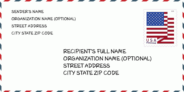
96734-49ND Envelope Example

-
This is an example of U.S envelope. Fill in the sender's information at the top left and the recipient information at the bottom right. The necessary information is sender/recipient's full name, street address, city, state and zip code. The recipient address information has been given for your reference. Generally, If you are not sure of the full 9-digit zip code, you can only fill in the 5-digit zip code to avoid loss of package.
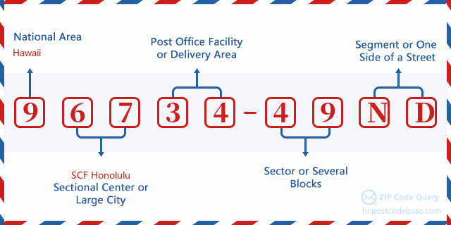
96734-49ND Basic Meaning
-
What does each digit of ZIP Code 96734-49ND stands for? ZIP+4 Code consists of two parts, the first five digits can be located to the post office, and the last four digits can identify a geographic segment within the five-digit delivery area. The 6-7 digits designate sector or several blocks, and the 8-9 digits designate segment or one side of a street.

Online Map

This is online map of the address 2500 MANNING CIR, KAILUA. You may use button to move and zoom in / out. The map information is for reference only.
Address: 2500 (From 2500 To 2599) MANNING CIR, KAILUA, HI 96734-49ND, USA
Comment


Add new comment